A journey of a thousand miles begins with a single step (Lao Tzu)

Sunday 21 October 2012

One big day.


If you've followed our progress on the website/Facebook/twitter, you'll know by now that we completed our 3 peaks challenge in 26 hours. A bit disappointing to be a couple of hours out, but elated that we have raised over £5000.00 on the just giving site already. There is still some money to come in from our individual sponsors so we are not sure of the full total raised yet, needless to say a massive thank you to ALL our sponsors, I'm sure Cancer Research UK will be delighted with the total.

Rather than describe our adventure blow by blow, we decided to put all the video and photos together into a short film clip and that will be on the website in the near future and possibly on this blog page too. We all had an amazing time, it was very hard going sometimes but an experience that it would be difficult to replicate.

I can't speak for the others, but here are a few of my personal highlights that will stay with me forever.

  • Introducing the guys to Steel Panther on the way to Fort William.

  • Climbing Ben Nevis.

  • Photographing a wild stag on Ben Nevis (it was only on a compact camera, I'll be back to make a proper job of it one day).

  • The blizzard at the summit of Ben Nevis.

  •  Dave's epic drive from Ben Nevis to Scafell Pike.

  • A clear sky on Scafell Pike, (look at those stars Joe! ).

  • Jason's pole dancing on Scafell.....bent one, snapped one! 

  • Painkillers by the dozen!

  • The views from Snowdon, the weather was most kind to us in Wales. 

  • Adrian's new collection.

  • Our collection of injuries, aches and pains.


Overall......a fantastic adventure with a great bunch of guys and we raised some money for a worthy charity.

We'd like to say big thank you to all the Sponsors and supporters of our trek, to Dave, who cornered startled celebrities and filmed them for the website and to all the guys went through different levels of pain to get from Scotland to Wales in one piece.

Chris

Monday 8 October 2012

To walk or not to walk?


To walk or not to walk, that was the question.

Just over a week to go until our 3 peaks challenge and the above was running through my mind. What if I turned my ankle took a fall and injured myself, what if I stumbled on a rock and fell…..yeah, what if!!!
Life’s a gamble and there’s only one certainty, at some point, some day it’s going to end. So what do you do? Hide away? Wrap yourself in cotton wool? Or get out there and enjoy it? The choice is yours. My choice was to go walking and so was Matt’s.
Where to go was the next question, last time when we just picked a start point and made it up as we went along proved to be pretty popular, well, with Matt and me it did. Start point chosen, the very charmingly named Cutthroat Bridge near Ladybower Reservoir. Pulling up at the lay-by near our start point, Matt’s face lit up, he’d spotted a burger van. So while I was lacing up the boots, he was pestering a rather cold looking burger/bacon/hot dog sales executive. He must have been the first customer of the day because it took quite a while for him to come back with a cob (it’s a cob, not a balm cake, roll or bap) and a coffee, which he polished off pretty quickly whilst deftly lacing up his boots.
We set off along the edge of the A57 and crossed it at the bridge. I had a rough idea where we were heading, but there were lots of options open, a full circuit, half circuit, walk by the reservoir or not, choices, choices. We started gaining height over fairly sodden ground at a decent pace, when I started getting pains in my shin area, like a sort of cramp and what was worse, it wouldn't go away. We reached Whinstone Lee Tor where I had to stop (a) to take some photos and (b) to adjust my boots, hopefully to ease the cramping in my shin. Whatever I did, it helped and the cramping feeling left as soon as it appeared.

Ladybower Reservoir from Whinstone Lee Tor.

The views were excellent, looking out over Ladybower Reservoir, over to Hope and Kinder Scout. There were low clouds, but this was making way for sunshine…..yet again brilliant weather (will I ever get to use my waterproofs). It was a bit breezy walking along the edge, as we passed some curiously shaped and named rock formations, Wheel stones, Salt Cellar, Dovestone Tor and Cakes of Bread. All the time, the views got better and better, being able to see clearly for 360 degrees was fantastic, especially at Back Tor which was the highest point we’d reach that day. It was here that we had to re fold the map to work out where to head next and for Matt to reach inside his rucksack and pull out….yes you guessed, a Ginsters. This time, it was a Peppered Beef slice, although he admitted that the Spicy chicken one was his favourite. I had a cereal bar L.

Wheelstone rocks.


Another odd shaped rock.


Cakes of bread.


We chose our next route and instead of following the blindingly, bleeding obvious path, we traipsed across the heather, noticing the error of our ways, we soon made our way back to the path. If anyone had been watching, our excuse was that we getting in some practice for Grouse beating for the local shoot. It must be trig points that confuse us, or ley lines…or holding the map the wrong way around.
We passed the Cairn at Lost Lad and headed towards Sheepfold Clough, where we would descend to Abbey Brook and follow this to Upper Derwent  Reservoir. All pretty standard really, beautiful countryside, babbling brooks and glorious weather. On reaching the edge of the reservoir, we decided that instead of walking alongside the waters, we would go back up to the high ground. A few spots of rain fell….that was all. We started the climb up Abbey Bank, which was steep and energy sapping until we arrived at Bamford House, it’s not really a house, more a collection of stones. We decide to stop for something to eat here and sat overlooking Derwent Reservoir when a light aircraft flew along the length of the water banking and turning as it went, if it had been a Lancaster Bomber I think I would have burst with pride, next time maybe.

A not so 'famous grouse'.

Re fuelled and ready to get going again we again decided to head for the high ground rather than down towards the waters edge. Matt must have had some serious energy food because he was on mission, striding out at a serious pace. Following in his wake, I managed to keep pace with him over the boggy, energy draining ground, occasionally stopping for a short breather until we reached the top edge just south of Back Tor. He admitted later that he was trying to see how fast he could walk, well the old git kept up with him. Keeping at a decent pace we walked back the way we had come across Derwent Edge, still marvelling at the now even clearer views under sunny skies. 

Back on the edge.

By now I was setting the pace and felt as good as I have ever done during the day, which must mean that I’m getting fitter, which is just as well really.
Walk done, 21.5km, no injuries, no blisters and no burger van when we got to the car, hey, you can’t have everything.
So, last walk before our big day next week, have they helped? Oh yes. Have we enjoyed them? Most definitely. Will we complete the 3 peaks next week…..you’ll have to follow us on the website to find out.

You can keep up with our progress on the 3 peaks challenge on Friday 12th October through twitter or facebook, both which feed onto the website.


Chris

Friday 28 September 2012

T'other side of Kinder.


Liner socks.....check.
Hiking socks.....check.
Insoles for boots.....check.
Blistop.....check.
Zinc Oxide tape.....check.
Something missing.......feet.....check.

Simple this walking lark really.

So, where this time, well unless you didn't read the title the answer is Kinder Scout, why, why not I say? Streams, rivers, rocks, views, peat bogs and the ever changing weather, what's not to like!
To make it a bit different, we decided to approach Kinder from a different angle, that angle being from the North. Matt decided on a cunning plan, if we didn't plan a route, we couldn't get lost.....simple, but brilliant. We're not too bad at this directional stuff by now, but we could say hand on heart that we didn't take a wrong path all day. That's fine, as long as we get back to the car sometime in the next few hours. Matt had chosen a starting point, so everything was good. Getting to the starting point took a little longer than expected due to Nottinghamshire's finest constables diverting our first attempt at getting to the motorway...'move along sonny, nothing to see here'.
We arrived at our destination at the Snake Inn on the Snake Pass (A57), kitted up, then dodged the speeding traffic, across the road and through the woods to the River Ashop. The intention was to climb up to the summit through Fairbrook, after that it could be left or right....ahh, the freedom!

Fairbrook and our destination in the distance.

We started the climb up Fairbrook, the weather was excellent, after the amount of rain that had fallen over the past few days/weeks and the dark skies, we were amazed that we were again looking at blue skies. It appears that the weather Gods are pleased with us, or, we are in for the mother of all downpours sometime soon...I fear it is the latter.
Fairbrook was a decent climb, with the last part near the summit more of a scramble over boulders and rocks than a steady plod.

Nearly there.

Reaching the top, we took a few minutes to get our breath and it was Ginsters time for Matt...a Cornish pastie on this occasion. After a few mouthfuls, he announced that it would have been better if it had been hot. You can carry your own microwave matey! Decision time, left or right, well depending on your point of view, we went right (with Fairbrook to our backs, left next time maybe). It was getting a bit breezy now, so the woolly hats came out...then the jackets. Although the views were stunning and clear, we could feel that the cloud level was about to descend upon us.

Ashop Moor where we would be walking later on in the day.

 Walking past Fairbrook Naze and along to The Edge (no U2 affiliation I think) it was still sunny and the views were fantastic. It was only when we looked back that we could see how far the cloud level had dropped, it was coming down rapidly, then the views disappeared as visibility was 20 metres at best.

A novelty shaped rock I named 'the Turtle's head'.

We'd decided to head for Kinder Downfall and as we would approach from the North, we could take in the views from a different perspective, that was the plan anyway. We carried on following the path at the edge of Kinder and hoped to find the Pennine Way which would lead us to our destination. Navigating in poor visibility is not the easiest task, especially when you can't make out any natural features, but we managed it fairly easily. The route along the Pennine Way was easy going, the fact that we couldn't see the views obscured by the low cloud, was frustrating.

The 'view' at Kinder Downfall.

Reaching Kinder Downfall we decided to have something to eat, Ginsters were not on the menu at this stage (think the special offer has finished). So we sat and looked at the view. A couple of walkers appeared through the cloud, a bit like when they appear on 'Stars in their eyes'. They had come from across the top of Kinder, a route that we have travelled a couple of times and we know that it's not the cleanest of places.....ask Adrian. But this guy was clean, show room clean, no peat on his shoes and not a splash of muck. His wife/girlfriend (we didn't get to find the level of the relationship, although judging by her face it was going to be a short relationship) looked like she was soaked, fed up and didn't want to be there. I asked if he had come across the top, to which he replied he had and that it was too bad! He must know a good route or he was wearing hover boots because even around the edges of Kinder it was like swamp land with all the rain we'd had. With a knowing smile they disappeared into the cloud.
  
After another 10 minutes we decided to get moving again, mainly because it was getting cold. We set off the same way we had come, along the Pennine Way, then as quickly as the cloud came down, it disappeared, revealing Kinder Reservoir and the surrounding landscape, but only briefly.

A brief lift in the cloud.

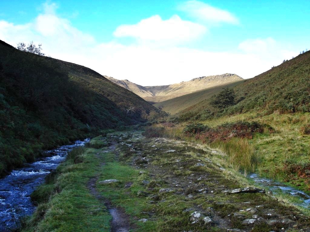
We followed the Pennine Way back to the point we had joined it earlier, the cloud had lifted a bit, so we could now make out some landmark features. Taking the path off from Kinder and down to Ashop Head (start of the River Ashop, or very near it), we walked close to the river. Not too sure if it was a path next to the river or whether it was part of the river because the ground was so sodden. The river almost runs parallel to the route we had taken up on the top of Kinder, so we were able to see where we had been as the cloud had almost gone and the sun was back out.

It wasn't too long before we were traversing sections of the river and its feeding tributaries further downstream, all good clean (or not so clean) fun. There was the second diversion of the day, rerouted around a section of forestry commission land due to a bit of tree felling. Tree felling!!!.... it looked more like a war zone, like a scene from Apocalypse Now. There was not a lot left. Walking a bit further we met one of the guys working at the site, who explained that most of the trees were ready to fall down, so they'd been tasked to cut them down. Apparently, the area will recover quickly, if not it will be re planted. We left to the sound of a chainsaw firing up.

Back up to the road, a bit of car dodging and we were finished. 18km walked and the best thing (for me) was no blisters, brilliant.


Chris.

Thursday 13 September 2012

Return of the Kinder Scout.


So, day two.

We'd decided to change from our original plan of a walk around Allgreave and the Roaches, considered by some to be one of the finer walks in the Peak District, our chance to comment on this would have to wait until another day. So Kinder Scout again, a few reasons why, Joe had never been, the weather was looking good, unresolved issues of navigation and to find the elusive 'path' across the top.

To make it a bit different this time we decided to go the opposite way around from our previous visit, although we would still be starting from Edale. So from the car park at Edale we headed into the very picturesque village and took a left onto the start of the Pennine way. Walking along here you get a great view of the Vale of Edale with Mam Tor and the great ridge behind, but it seemed noisier this time and it wasn't the sheep and cows (they were the rather pungent odour wafting about the place). The noise was coming from a helicopter that was landing in the Vale and then flew off in the direction of the top of Kinder. Whilst walking towards Upper Booth, the helicopter passed over or around us several times carrying large bags of materials to the summit. We later found out that they were carrying lime and fertiliser to the summit to sustain the grasses and peat that was being eroded away by wind and rain.


                                                    Walking along the Vale of  Edale.

We reached Upper Booth where we had a quick 5 minute break and guess what made its appearance.....a Ginster's beef slice this time. We had stopped at a small bridge where Crowden Brook flowed through, so this was now to be know as Ginster's Bridge and should anyone visit from now on, they should pay homage to the bridge by scoffing a pastie of some description and leaving a few crumbs. Back to reality, on we trekked towards Jacobs ladder, which Joe was particularly looking forward to due to our tales of woe when we came down it the last time. How he loved it, as did I, we both had issues with blisters and now they were becoming painful. We soldiered on, watching Matt and Adrian getting further ahead. We all rested at the top and were joined by three sheep who seemed to be strangely attracted to Adrian's nuts.......and raisins. As we set off again, the sheep disappeared, but after a while they came running after us. We came to the conclusion that they knew a lot of short cuts to jump out at hikers and relieve them of any food stuffs they were carrying, fortunately Matt had already eaten the gourmet part of  our food stocks, so they were left with healthy rubbish.

Not sure who's bothering who here !!!


Reaching Edale rocks, we carried on the Pennine way to find out where we had slightly taken a wrong turn last time. At the trig point at 633 metres we could see exactly where we had gone in the wrong direction last time. Never mind, we know now. Carrying on our way, the constant noise from the helicopter became louder and louder, in fact it was quite noisy along the top of Kinder with planes, helicopters and the odd rampaging sheep attack all contributing to the atmosphere of a nice quiet walk in the country.
The weather was superb again, but a bit windy along the edge, so the views across the countryside were as excellent as you could expect. Reaching Kinder Downfall, we decided to stop for lunch and blister watch. Lunch was good, blister watch wasn't so good. Yesterday's bad boy had got worse and was sore, so plenty of patching up was required. It was now apparent where the helicopter was dropping off its payload, about a kilometre away from where we were sat. I'd estimate that it was about 5 to 10 minutes from pick up to drop off for each load, it'd taken us about 2 and a half hours to get here and he was going further across the Vale of Edale than we had walked from. Maybe he'd like to assist with our 3 peaks walk, 2 hours job done.


                                                        Wasps, don't ya love em?


So now we were going to attempt to find the so called path across to Crowden Tower, at least this time there was no low cloud and we could see where we were going. This made it a lot easier. We stuck to a compass bearing and looked for features we could head for. The ground was a bit firmer this time around, so there was no being buried up to your knees this time (Adrian), that said a few hairy moments were had. Confident that we had cracked this navigation lark we stuck to our course, despite seeing scatterings of  people reading maps and pointing at all angles, we were right and they were lost we kept telling ourselves. It proved to be right, we reached the partly dried up stream bed of Crowden Brook which would lead us to Crowden Tower.

Peat, Gritstone and sky.

The idea was to walk along towards Grindsbrook Clough and then back down to Edale. But being able to change a route when you feel like it has it's benefits, but i guess it could have its downfalls too. It was all benefits this time, we chose to go down Crowden Brook to Upper Booth (land of Ginster's Bridge). With Joe leading down the Brook like a mountain goat, we did our best to keep up with him. It was tough going in places, with some steep drops, slippy rocks and a few ankle breakers lurking along the way. At one of the steepest parts and whilst stretching for a decent foothold, a strange ripping sound could be heard, initially I thought it was my knee or hip (being not as flexible as I once was, if I ever was), but it was my trousers. The draft was nice though.
It was tough going, all the way to Upper Booth, but very enjoyable, must try going up next time.

Adrian on his way down Crowden Brook.

From Upper Booth it was back the way we had come along the first stretch of the Pennine way, with the helicopter still buzzing above us like an annoying wasp we entered Edale, a bit footsore but having had another brilliant walk, in brilliant weather, in beautiful surroundings.


Add caption


ENDOMONDO TIME.
The data seemed to stop working for the drop down Crowden Brook (I think I may have paused it before we started on our way down by mistake), but it gives you an idea of the route. The wavy green line at the bottom is my heart rate, I needed to be revived on several occasions.


Chris

Monday 10 September 2012

Goyt Valley.

First walk for a couple of weeks, so why not do two.....great idea.

Matt and myself had looked at two walks over two days, mine was around Goyt Valley which included Fernilee and Errwood reservoirs, with Matt's taking in Allgreave and the Roaches.

Day one, Goyt Valley.

Traffic was really bad leaving Nottingham, it's amazing how much busier the roads are when the kids are back at school, so we didn't get to the car park until about 9.30 ish, Adrian was already there when Joe, Matt and myself rolled up. After a brief discussion about the cheap phone charger I had bought and had failed on the way, leaving me with no phone, no sat nav and worst of all, no ENDOMONDO (other tracking software is available), we set off. We started from a car park next to a small pond/lake/pool which is west of Buxton before the reservoir at Errwood. Heading down and across Wildmoorstone Brook and on towards Wild Moor, everything was fairly easy going and we had a steep climb ahead of us. It didn't look too bad initially, that was until we started climbing it. It was tough going to say the least, short but pretty painful, for me anyway. I got to the top of the steepest part and just had to sit down. I was trying to get air into my lungs because my head was spinning and I felt sick. The others took one look at me and asked if I was alright? My response, between gasping for air was something along the lines of "I'm not sure if I am going to puke or shit myself".....I really did feel that bad. A few minutes of heavy breathing and I felt much better, never felt that way before and don't particularly want to feel like that again. We continued the climb over Wild Moor with no more untoward events, apart from disturbing the local Grouse population who let us know about it in no uncertain terms.

In among the Grouse on Wild Moor.


Crossing a small footbridge we arrived at Goytsclough Quarry where we decided to a have a quick break before moving on. Adrian pulls out a bag of mixed nuts and raisins, Joe had a sandwich, I had a  muesli type bar and Matt pulls out a really healthy looking Ginsters chicken slice...well, it was cheap he said. After demolishing the Ginsters, we walked on towards Errwood Hall, after there, it was all uphill towards Shining Tor. The views from here were amazing as it was such a clear day. After much deliberation of where in the UK we were looking over we decided that we should have paid more attention in geography lessons in school. We carried along the ridge towards The Tors and Cats Tor, where we met a lone man who started chatting with us. He seemed to know the area very well and pointed out to the more geographically challenged of us, that the two major Cities/Towns we could see were indeed Manchester and Macclesfield. He then began to give us his life story and our eyes glazed over. It turned out that he was a magician, we said that we were too and promptly vanished!

The weary walkers arrive at Shining Tor.


That's Manchester in the distance....or was it Scunthorpe?

For a bite to eat, we stopped along the ridge looking out over Errwood reservoir. It was a brilliant view on a really clear sunny day. It was about this time that I thought I'd better check my feet for blisters. Having used the Blistop (bought for me by my lovely wife, see previous blogs) early in the morning I was hoping for an absence of the little buggers. There were none where I usually get them, happy days, but there was the blister from hell on my heel. I patched it up with a blister plaster. I think it was caused by my boot being slightly looser than normal, school boy error. Joe had a nasty toe blister which he tended to and then we were off again. It was decided that because of the lateness of arriving, that rather than walking in the direction of Fernilee, that we would head off the ridge and down towards Errwood reservoir. A short time later we were at the road that crossed between Errwood and Fernilee reservoirs where we spent several minutes marvelling at the engineering of the dam and it's sluice....that's what us engineers do you know....marvel at engineering things, mainly because we know of the hard work that's gone into it and the possible cock ups along the way!


Errwood Reservoir.

Fernilee Reservoir.


From here we circumnavigated (big word time) Bunsal Cob and made our way up to the car park where we started. Again, the weather had been superb and we'd had a really good day (barring blisters) it seems that the sun is really shining on us, no doubt before we get the drenching of our lives at some point.
During the days journey, we'd decided to shelf the walk that Matt had planned and revisit KInder Scout, mainly because Joe hadn't been there before and the weather was looking like it was going to be another glorious day.


Not sure about the Max speed on this, but as you can see on Matt's ENDOMONDO by eating a Ginster's Chicken slice you have to walk about 15km to negate the calorie intake!!!!


Coming soon...............return to Kinder, the sequel, part deux, take two...another chance to see etc.

Chris


Tuesday 4 September 2012

Here's hoping!!

Regular readers of the blog will now be quite familiar with my little problem with blisters (probably quite fed up with them too). Well, over the next couple of days we have planned two 20k walks in Derbyshire to build up the stamina for the big day, so if the usual pattern applies, I'll have the dreaded pus balls on my feet after the first 10k. In order that my colleagues are (1) not kept waiting (2) not in stitches at my attempts to walk on my hands, I've taken the followings steps (pardon the pun). New insoles with a gel backing, boots now feel tighter....less movement, less friction, reduction in the cause of the problem....hurray I hear you cry, the lad has cracked it...well, we'll see about that!
The other step (ha, two puns), was bought for me by my wife, probably because she's sick of watching me hobble around the house after our walking adventures, it wouldn't be because I ever mention anything about the golf balls on the soles of my feet, because I don't.....much. What is this miraculous prevention method you might be thinking, you might be, but you might be thinking 'why am I reading about some stupid bloke with soft girls feet', so, who's the strangest, me for writing about it or you for reading it? I digress, it's a spray that claims to prevent blisters called Blistop.


Not sure about walking around Derbyshire in red heels, but if that's what it takes, I'm game for it. No doubt I shall be telling tales of our days out and of any amusing incidents involving our merry band of  intrepid foot sloggers, high heels or not!

Chris.


Friday 24 August 2012

Epic climb and Epic read.

Ennerdale....not Emmerdale....heathens!!!

Words and Pictures from the Northern Rock lickers!!

Ennerdale is a fabulous valley separated from Styehead Tarn by a feature known as Windy Gap.....and yes, it is! It can be accessed by a longish walk in from the Ennerdale Water end or more directly via Scarth Gap from Gatesgarth Farm, which takes you up along side Haystacks and then back down into the valley, about 450 metres of ascent, with 350 metres of descent (that's right, the valley is higher on the Ennerdale side). Not having been for a proper rock climb for some time, Ian and I decided we would combine an overnight wild camp in Ennerdale, not far from the most remote YH in the country , with a revisit to one of our previous expeditions to Pillar Rock. Saturday morning, my phone alarm doing its best to wake me up at half past five, and it suddenly struck me that going for a few pints the night before probably wasn't my best move. Still, I was up, and I had packed my gear on Thursday (missing out some fairly important items as it happens, more of that later). A bit of stumbling around, breakfast, tripped over the cats a few times and eventually got my self out and across to Ian's for seven. A bit more bumbling around and we were off. Two hours later we parked up in a farmers camp site field, geared up, and after a bit of a chin wag with a holidaying Scouser, we were on our way.


Ennerdale Camp.

We were both carrying about 17kg, with the majority of mine being the tent and climbing rack, and Ian's being the food, cooking clobber and the rope. Of course, on top of that, we were both carrying sleeping bags, sleeping mats, water proofs, climbing shoes and harness, drinks and scoff for the days adventure. The walk up to the gap is quite steep in places, and with the intense mid morning sun and the substantial loads, it was heavy going. I must confess, it was quite a relief to find ourselves finally on the top of the gap with the knee crunching and thigh stretching descent between us and the valley below. Over the last few years I have been trying to use my walking poles less and less in an effort to increase my leg strength, and I think this has been successful to some degree. However, on this occasion I was only too willing to take all the help I could get, and shamefully employed my poles with gusto, allowing me to float up, then down, on wings of gossamer and helium...... and Slipknot are known for their cello recitals. The walk down into the valley isn't too bad really, and is improved by the views of Pillar on the opposite side about 5 km to the south west, this being our ultimate goal for the day. So, soaking wet with sweat, we walked past the Black Sail youth hostel and on towards a small footbridge crossing the inviting, crystal clear water of the River Liza (I only know that because I just checked the map!). Another five minutes and we reached our camp site on the opposite bank to the hostel. I suppose you can guess the level of relief you feel when you first drop your rucksack after a heavy weight amble? If you can't, you have never lived! Within the hour the tent was up, bait had been scoffed, and my 55 litre rucksack was repacked with the climbing essentials, more scoff and the standard outdoors clobber. We had decided that for this part of the trip we would take it in turns to carry either the rucksack or the rope and swap regularly. ONWARDS! The initial ascent follows a water course called Sail Beck, which is the result of mountain water run off from Kirk Fell. It's a real slog, but gets you up to 600 metres fairly quickly.


The path to Scarth Gap.


 From this point forward we walked parallel to the valley floor along the high level traverse for about 4km until the path starts to descend back down to 500 metres and brings you round to the buttress known as Pillar Rock, standing apart from Pillar itself. Deftly (i.e., didn't fall over too often) we moved with purpose (i.e., stumbled) up the scree gulley to the climb starting point. Big boots off and in the rucksack, climbing shoes and harness on, the ensemble completed by festooning ourselves with Dyneema slings, carabiners, quick draws, cams, nuts on wires, belay devices .....errrm,.......oh yeah, and the rope of course. As previously mentioned, we had done this route before, but as a trio with another climbing chum, and in that configuration whoever goes first (leads) has to stay at the front. At the time I didn't clock that one until I was on the second pitch of the climb and ended up having to lead the whole climb. I never said I was bright. This time though, Ian was going to lead and I would "second" carrying the rucksack. Rock Climbing 101: Usually you climb as a pair. Both tied in to opposite ends of the rope. The leader climbs first putting in protection such as nuts, cams, hexes, slings on projections or threads, and attaches these to "runners" (quick draws, which are a pair of spring gated carabiners connected by either a nylon or Dyneema sling, protection in one end and the rope clipped through the other). As the leader ascends, the rope travels with him, and if he falls, the second can stop the rope paying out, braking with the belay device. As long as the protection holds, everyone is happy..... So, assuming the leader hasn't taken a fall, he gets to a suitable point in the climb where he can make a nice secure anchored position, then covers the ascent of the second climber using his own belay device. As the second ascends, he takes the protection back out again. This is classed as multi pitch climbing, and in this way you can climb routes hundreds of metres long with a 50 metre rope. But, I digress. Ian is off like a rocket, hurtling up the vertical face like he's out for a jog (this is nothing new by the way), stopping occasionally to slot a cam into a deep enough gap or dropping a sling over a robust rock spike. All was going well for the first three pitches, with me safely tucked up in the bottom of a chimney, anchored in on an absolutely bomb proof chock stone thread, and Ian mooching around above me pushing the envelope. And then I noticed that Ian had disappeared out of the chimney, not that I was worried, the rope was still paying out, he was still making progress..... Now, as I recalled, the route went straight up from this point and I fully expected to be able to see Ian most of the way up on the last two remaining pitches....And the rope was still paying out.... and there was only 3 metres left. "Ian"' I shouted, "3 metres left". The distant response of "Oh, bugger" drifted down to me from high on my right as I faced into the chimney. Everything seemed to stop for a while, clearly there was something going off I didn't understand and my last shouted communication with Ian did not bode well. "Oh, bugger" I repeated Ian's mantra to myself, starting to feel a bit alone. Fear is a funny thing, you keep telling yourself that all is well, that you are within 50 metres of the top, that you are so well secured there is nothing to fret about, that the Mountain Rescue Team are really a jolly bunch of chaps whom you will never need to make the acquaintance of, and then, inexplicably, your mouth does an impersonation of Death Valley... And then Ian shouts for you to take in the slack, which means he is moving again, just in the wrong direction. Anyway, whatever the problem was (I will find out later), he confirms that he is safe, and that I can take him off belay. He takes in the slack then gives me a call of "climb when ready", to which I respond with "climbing" as I take out the thread anchor, and I'm off. And then it starts to become clear. The chimney above is soaking wet, so Ian had traversed off to the right around three vertical ribs of rock with small grassy ledges between each one.

                                                               Climbing Pillar Rock


 You can't see around the ribs, you can only feel for the holds, its like trying to find a light switch on the other side of the door frame while standing on roller skates, and with the rucksack dragging me off balance, it would be fair to say it played with my confidence a teensy weensy little bit. And that was with a rope on me, so it was probably even less pleasant for Ian, because if he had taken a fall, the last bit of protection was about 10 metres back, and it would have resulted in a long pendulum swing. And he would have been only too aware of this. As I finally swung around the final rib, with the weight of my rucksack adding to my momentum, Ian's big cheesey grin came into view. "Exciting, eh? Wasn't sure if you would make it around the traverse!". He wasn't the only one. I re-anchored on a wicked big sling and spike arrangement, passed on the protection gear that I had retrieved and he was off again on the last pitch. And the scarey traverse was worth the effort, the last pitch was glorious, near vertical, huge drops wherever you looked, nothing except fresh air under your heels, excellent grippy rock, and surprisingly easy climbing straight up. On the top of High Man, a 5 minute breather while we pack up our gear and change into our boots. Oh, the relief, climbing shoes are the most unnatural, uncomfortable bits of leather and rubber you can cram your tootsies into. Try it sometime, you will not be disappointed. All secured, we follow the classic scramble route of Notch and Slab off the top (very steep and exposed, and all down climbing, did I mention I hate down climbing?), then on to the path that takes you to the top of Pillar itself. Another half hour of upward slog and there is the deserted trig point. Hurrah. Views? Yes, there were some of those.


Back down the Gap

.
 You could even just about see the Youth Hostel close to where we had camped back down on the valley floor. As our friend Bazz once aptly commented, "it looks so impossibly far away". After a half a Mars bar each, we set off on our return leg, which follows a particularly good path right across the top, losing 300 metres height over 4km until we finally pick up the 600 metre direct descent route back to the valley floor. And the tent was still there, BONUS! I think by now it was getting on for just after 17:00, so a quick splash around in the river, then Ian started making our evening meal. For starters, spicey Butternut Squash soup followed by Spinach and Ricotta pasta with a pokey sauce. Then Ian pulls out two small bottles of red wine to go with the pasta, an excellent and most welcome surprise. It was at this point I realised I had forgotten to bring my camping plate, mug and cutlery, but never fear, I just scoffed mine straight out of the pan (scruffy bugger that I am). Bit of a tidy up, and while Ian got a proper camp fire going I sorted out and repacked the climbing gear. The rest of the night we sat around the fire drinking hot chocolate with brandy - mine out of a pan of course -(about 50/50 the way I felt the following morning) yakking about our glorious conquest, although it may as well have been the north face of The Eiger by the time the brandy was finished. I think I was spark out before 22:00, and before I knew it, it was 07:00 and the camp site was being investigated by a pair of large, intimidating and inquisitive bulls. Fortunately, after realising that all the brandy had gone, they decided to look elsewhere. Just over an hour later, everything was back in the rucksacks and we were on our way, full of great ideas about doing Scafell Pike via Wasdale before going home. By the time we got to the top of Scarth Gap this had changed to breakfast at the cafe in the George Fischer outdoors shop in Keswick with potential for spending money in other establishments of daylight robbery that abound in the same town. An uneventful but tiring descent, passing lots of people moving in the opposite direction and we were back to the car. A short drive in to Keswick and breakfast shortly followed. Revived to some degree by excellent coffee and toasted tea cakes, a short wander around the purveyors Event and Gortex ensued. It was here that Ian found and purchased his new foldaway baseball hat, of such ingenious design that the architect of said item must have been on for a Nobel Prize (according to Ian). We then hobbled back to the car (well, I hobbled, Ian strode with great purpose, wondering why no one was paying any attention to his new hat), made our excuses to no one in particular, and I drove us home using a clever arrangement of broom handles and string to operate the pedals (damn those climbing shoes). Overall, a fantastic weekend of high adventure, punctuated by moments of alcoholic indifference, raging camp fires, nosey bulls and consumerism of the worst kind. It could not have been any better really....... could it? Nah, not a chance!


Robin ( with all the hard work done by Ian).